Famous Ships, Foster City
Updated · 5,204 residents
Famous Ships is a highly walkable, waterfront neighborhood characterized by a diverse mix of townhomes and single-family residences. Residents benefit from an extensive network of pedestrian pathways, proximity to local parks, and a vibrant suburban atmosphere that is exceptionally dog-friendly.
Key Highlights
About Famous Ships
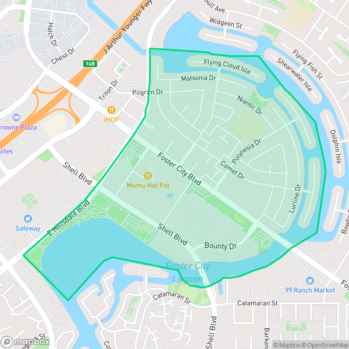
Famous Ships (also known as Neighborhood #1 or Treasure Isle) is Foster City’s oldest residential neighborhood. Developed primarily between 1963 and 1965, its layout features streets named after historic vessels like the Niantic, Balclutha, and Pilgrim. On March 7, 1964, the family of Charles Zerbe moved into a Kay Builders home on Pilgrim Drive, becoming the city’s very first full-time residents. To prevent a uniform aesthetic, city founder T. Jack Foster commissioned three distinct homebuilders: Kay Builders, Duc and Elliot, and renowned mid-century modernist Joseph Eichler, whose local designs were led by architect Claude Oakland. Spanning three of the city's original engineered islands, the neighborhood is also home to Erckenbrack Park—Foster City's first waterfront public space—and Brewer Island Elementary School.
The neighborhood maintains a distinct suburban character defined by its integration of residential living and water features. With a high walkability score, the area offers a continuous network of sidewalks and pedestrian bridges that connect homes to local amenities, including restaurants and community hubs like the Island United Church. The visual landscape is defined by varied architectural styles, including mid-century modern designs, and well-maintained green spaces that contribute to a high quality of life for residents.
For those considering a move to the area, it offers a balance of community engagement and suburban convenience, though the density of housing means that some residents may experience limited privacy in shared-wall complexes. While the neighborhood is largely peaceful, road traffic contributes to moderate noise levels. According to iHuus data, the area is well-suited for those prioritizing outdoor access and proximity to high-performing schools, such as the highly-rated Brewer Island Elementary.
Neighborhood Scores Across 15 Qualities
Residential spacing varies between shared walls in townhomes and detached houses with moderate buffers, though overall privacy is slightly lower than the Foster City average according to iHuus data.
Continuous sidewalks, pedestrian bridges, and dedicated shoreline paths provide an excellent environment for walking. This connectivity is nearly identical to the Foster City average.
Waterfront properties featuring complex rooflines and private docks define much of this area. While the visual quality is slightly below the city average, the neighborhood still offers high-end amenities such as shared luxury pools and tennis courts.
Extensive waterfront trails, interconnected green belts, and large shoreline parks provide ample space for pet owners. According to iHuus data, these amenities offer a level of accessibility for walking dogs that is consistent with the rest of Foster City.
Suburban development dominates this area, featuring a variety of single-family homes, townhomes, and multi-story apartment complexes. This built environment is largely consistent with the broader Foster City area.
Active streets and green spaces provide a higher concentration of local dining and social spots than the Foster City average. Residents can access various community landmarks, such as Erckenbrack Park and nearby cafes, within a balanced suburban landscape.
Steady sounds from nearby busy streets create a noticeable hum. This level of acoustic activity is slightly higher than the average found throughout Foster City, according to iHuus data.
Air quality in this area is consistent with the Foster City average, presenting a mix of acceptable and unhealthy days that may occasionally affect sensitive groups.
No warehouses, industrial facilities, or hazardous sites are present in this area. The neighborhood maintains a strictly residential and recreational land use, matching the city average for industrial proximity.
Nearly all residents have access to health insurance, a rate that is nearly identical to the Foster City average according to iHuus data.
Voting patterns and census indicators show a predominantly liberal leaning that is consistent with the rest of Foster City. This political profile aligns closely with the city average according to iHuus data.
Residents live alongside a balanced mix of young adults, families, and older populations, matching the typical age distribution found across Foster City.
Residual flood risks exist due to the area being within a 500-year floodplain, though safety levels are slightly higher than the Foster City average according to iHuus data.
Address-Level Insights for Famous Ships


iHuus Neighborhood Intelligence Insights
Get address-level neighborhood insights for Famous Ships
- Street-level scores — see how individual blocks compare, not just neighborhood averages
- Micro-zone boundaries — identify quiet pockets, flood boundaries, and walkable clusters before you visit
- 15 dimensions in full — walkability, noise, air quality, school quality, insurance coverage, population age profile, urban/rural index, and more
- Boundary risk alerts — know if your address sits near a block boundary where scores drop, the kind of detail no listing will ever mention
- School insights — individual school ratings and insights, not just district-level data
- Compare before you commit — side-by-side data across neighborhoods, down to block precision
No credit card required
Compare with Any Neighborhood
| Dimension | Famous Ships | Admirals |
|---|---|---|
| 🚶 Walkabilityavg 9.66 | ||
| 🔊 Acoustic Comfortavg 5.36 | ||
| 🤫 Privacy Indexavg 4.79 | ||
| 🎨 Visual Appealavg 7.56 | ||
| 🐕 Dog Friendlinessavg 8.13 | ||
| 🗺️ Urban-Rural Indexavg 6.57 | ||
| ✨ Neighborhood Vibeavg 5.89 | ||
| 🏥 Health Insurance Coverageavg 9.32 | ||
| 🌿 Air Qualityavg 6 | ||
| 🏭 Industrial Proximityavg 9.99 | ||
| 🌊 Flood Safetyavg 7.51 | ||
| 🗳️ Ideological Leanavg 9.61 | ||
| 👥 Population Age Profileavg 4.98 | ||
| 🔥 Fire Safety | ||
| 🏫 School Quality |
Famous Ships Rankings
School Districts Serving Famous Ships
School Insights for Famous Ships
Below average outcomes; significant attendance and academic challenges.
School Insights
See what's really behind every school rating near Famous Ships
- Individual school ratings — each school's own score with outcome context, not just a district average
- Enrollment & class size data — student-to-teacher ratio and how it compares to the state average
- Full demographics breakdown — ethnicity and gender composition for every school in the enrollment zone
- Every school in the district — all schools within the enrollment boundary ranked by rating, not just the closest one
- Grade levels & benchmarks — elementary through high school, with below/above state-average flags
No credit card required