Tyner Homes, Bakersfield
Updated June 22, 2026 · 2,768 residents
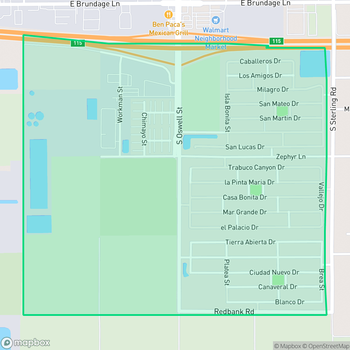
Tyner Homes is a residential neighborhood in Bakersfield characterized by a dense suburban layout of uniform tract housing. While the area offers complete sidewalk networks for pedestrians, residents should be aware of significant noise levels from nearby road traffic and limited privacy due to the close proximity of homes.
Key Highlights
About Tyner Homes
Tyner Homes is a suburban community primarily defined by its standard tract housing and proximity to major transit corridors. The area features a consistent layout with small backyards and a high-density footprint, creating a uniform visual environment. Residents have access to local amenities such as Ben Paca Mexican Grill and Panda Express, though the neighborhood remains relatively quiet with limited commercial density. According to iHuus data, the area maintains a high walkability score due to its complete sidewalk infrastructure, although the presence of a nearby highway creates a distinct physical barrier within the community.
Living in this neighborhood involves specific trade-offs regarding acoustic comfort and environmental safety. The area experiences elevated noise levels primarily driven by road traffic, and residents should note that the location faces challenges regarding flood and fire safety. While the neighborhood provides a stable, quiet environment for those seeking a suburban lifestyle, it is best suited for individuals who prioritize walkability and proximity to essential infrastructure over absolute quiet or extensive private outdoor space.
Neighborhood Scores Across 15 Qualities
Residential spacing is tighter than the Bakersfield average, featuring high density clusters and homes positioned closely to one another. Some areas near industrial lots lack significant buffers between neighbors.
Residential blocks feature sidewalk networks, but connectivity is limited by a high speed highway and dirt shoulders on nearby arterial roads. This level of walkability is lower than the typical Bakersfield average, according to iHuus data.
Standard tract housing dominates the area with uniform rooflines and small yards. Some parts of the neighborhood contain unpaved lots and visible debris, making the visual landscape less polished than the Bakersfield average.
Walking routes for pets are somewhat restricted due to narrow residential verges and a lack of widespread green space. While a central neighborhood park and continuous sidewalks provide some utility, overall dog friendliness is below the Bakersfield average according to iHuus data.
Open agricultural lands and scattered structures characterize the landscape, providing a semi-rural atmosphere that is slightly more open than the Bakersfield average. According to iHuus data, the area features a mix of agricultural fields and low-density utility land.
Low density housing and industrial zones create a tranquil environment, though local activity and business access are notably lower than the Bakersfield average. According to iHuus data, the area is characterized by vast open spaces and limited social hubs.
Persistent noise from nearby airport runways and heavy rail infrastructure makes this area significantly louder than the Bakersfield average. Residents should expect constant acoustic disruptions according to iHuus data.
Air quality is consistently high with infrequent periods of poor visibility or pollutants. This level of air clarity is roughly in line with the Bakersfield average according to iHuus data.
Residential areas remain primarily quiet, though some western edges feature warehouses and storage facilities near the highway. This level of industrial proximity is lower than the Bakersfield average due to the presence of nearby wastewater treatment infrastructure and large-scale basins.
Health insurance accessibility is below the Bakersfield average, with fewer residents in this area holding coverage compared to the rest of the city.
Political leanings in this area trend significantly more liberal than the Bakersfield average, according to iHuus data.
Residents live alongside a balanced mix of young adults, families, and older individuals. This demographic variety is slightly lower than the Bakersfield average according to iHuus data.
Flood vulnerability is significantly higher here than the Bakersfield average, according to iHuus data. Residents should be aware of substantial seasonal flood risks when considering properties in this area.
Block-Level Insights for Tyner Homes

iHuus Neighborhood Intelligence Insights
Get block-level neighborhood insights for Tyner Homes
- Street-level scores — see how individual blocks compare, not just neighborhood averages
- Micro-zone boundaries — identify quiet pockets, flood boundaries, and walkable clusters before you visit
- 15 dimensions in full — walkability, noise, air quality, school quality, insurance coverage, population age profile, urban/rural index, and more
- Boundary risk alerts — know if your address sits near a block boundary where scores drop, the kind of detail no listing will ever mention
- School insights — individual school ratings and insights, not just district-level data
- Compare before you commit — side-by-side data across neighborhoods, down to block precision
No credit card required
Compare with Any Neighborhood
| Dimension | Tyner Homes | Amberton |
|---|---|---|
| 🚶 Walkabilityavg 8.36 | ||
| 🔊 Acoustic Comfortavg 3.78 | ||
| 🤫 Privacy Indexavg 5.57 | ||
| 🎨 Visual Appealavg 6.61 | ||
| 🐕 Dog Friendlinessavg 6.03 | ||
| 🗺️ Urban-Rural Indexavg 6.87 | ||
| ✨ Neighborhood Vibeavg 4.25 | ||
| 🏥 Health Insurance Coverageavg 6.62 | ||
| 🌿 Air Qualityavg 8.49 | ||
| 🏭 Industrial Proximityavg 8.26 | ||
| 🌊 Flood Safetyavg 3.54 | ||
| 🗳️ Ideological Leanavg 5.07 | ||
| 👥 Population Age Profileavg 4.44 | ||
| 🔥 Fire Safetyavg 0.11 | ||
| 🏫 School Quality |
Tyner Homes Rankings
School Districts Serving Tyner Homes
Fairfax Elementary School District operates as a stable but academically challenged 'Mixed/Transition' organization, characterized by a significant performance gap between its solid elementary schools and its struggling junior high. While the district benefits from a tight-knit community, low suspension rates, and recent successes in securing technology grants and facilities upgrades, it is hindered by 'Orange' level state dashboard ratings in math and reading and looming budget constraints. Leadership has shown competence in reducing chronic absenteeism and maintaining infrastructure, but the district lacks the high-tier academic results or terminal school consistency required for a higher rating.
Schools
Kern High School District is a robust, operationally stable organization that functions as a 'Mixed' portfolio of high-performing flagship schools and underperforming rural campuses. While the district earns praise for its Career Technical Education (CTE), high graduation rates, and competitive athletics, it is hampered by a stark disparity in academic proficiency, with several schools reporting math and reading scores well below state averages. Despite these academic gaps, strong teacher retention strategies and successful specialized programs like the Academic Decathlon indicate a stable corporate foundation that manages a diverse and geographically vast student population effectively, though it lacks the uniform excellence required for a higher rating.
Schools
Bakersfield City School District is characterized as a 'Distressed' organization where strong operational efforts in facility modernization and labor relations are overshadowed by systemic academic underperformance and stability issues. While recent investments in literacy and campus security show a commitment to improvement, the ground truth data reveals that a vast majority of the district's schools are performing at the lowest state percentiles. Frequent teacher turnover and significant concerns regarding middle school discipline suggest a fractured operational environment that has yet to translate into consistent academic success across its diverse portfolio. The district remains a system in transition, struggling to reconcile its high-performing magnets with the persistent challenges facing its Title I campuses.
Schools
School Insights for Tyner Homes
Below average outcomes; significant attendance and academic challenges.
School Insights
See what's really behind every school rating near Tyner Homes
- Individual school ratings — each school's own score with outcome context, not just a district average
- Enrollment & class size data — student-to-teacher ratio and how it compares to the state average
- Full demographics breakdown — ethnicity and gender composition for every school in the enrollment zone
- Every school in the district — all schools within the enrollment boundary ranked by rating, not just the closest one
- Grade levels & benchmarks — elementary through high school, with below/above state-average flags
No credit card required