Riviera - Westchester, Bakersfield
Updated June 22, 2026 · 4,900 residents
Riviera - Westchester is a historically significant area known for its diverse architectural styles and mature, tree-lined streets. According to iHuus data, the neighborhood offers a higher level of visual appeal and flood safety than the Bakersfield average, though residents should expect moderate noise levels from local road traffic.
Key Highlights
About Riviera - Westchester
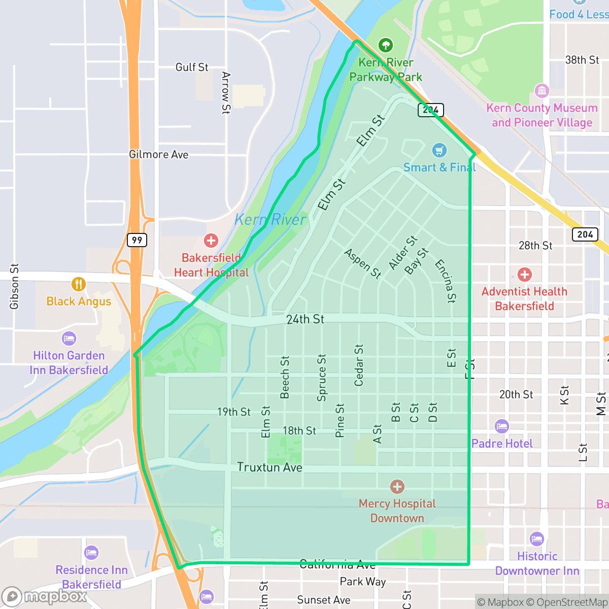
The Riviera - Westchester neighborhood in Bakersfield, California, is one of the city's earliest residential areas, formed by the fusion of two adjacent historic districts: Westchester, situated west of F Street, and Riviera, located along Elm Street near the Kern River. Developed in the early 20th century, the neighborhood is celebrated for its mature, tree-lined streets and diverse architectural stock, which includes turn-of-the-century Tudor-style residences, classic California bungalows, and mid-century ranch homes. Key local landmarks include Jastro Park, established in 1917, and Beale Park, both featuring historic outdoor amphitheaters. The neighborhood's distinct community character is further anchored by long-standing local businesses along F Street, such as Rosemary's Family Creamery, which has served the community since 1984, and Bonnie's Best Cafe, established in 1997.
The neighborhood maintains a distinct identity through its blend of residential charm and active commercial hubs. While the area features a variety of local dining options such as Athena's Greek Cafe and Locale Farm To Table, the layout remains largely car-dependent despite its respectable walkability score. The environment is characterized by a mix of residential streets and light industrial or commercial units, creating a lively atmosphere that balances quiet, tree-lined blocks with the energy of nearby social centers and railway-adjacent corridors. Residents benefit from high rates of health insurance coverage and a robust sense of security regarding flood risks, which significantly outperform broader city metrics.
Prospective residents should consider that the area experiences moderate noise levels, primarily driven by road traffic, which is a common trade-off for its central location. While the neighborhood boasts high visual appeal, dog friendliness is slightly lower than the city average, and the fire safety profile reflects the broader regional challenges found throughout Bakersfield. Educational opportunities are varied, as the area is served by multiple school districts with differing performance ratings, ranging from high-performing options like the Fruitvale Elementary School District to districts currently undergoing transition. Overall, the neighborhood is well-suited for those seeking a historic aesthetic and community-oriented lifestyle with convenient access to local services.
Neighborhood Scores Across 15 Qualities
Residential lots feature a mix of density, ranging from closely packed houses with minimal buffering to areas with more separation between neighbors. This level of privacy is roughly in line with the Bakersfield average, according to iHuus data.
Sidewalks and marked crosswalks are consistently available along residential and commercial streets, although walkability is slightly lower than the Bakersfield average. Residents can expect a reliable grid for navigating the area on foot.
Residential streetscapes feature uniform tract housing and modest lot sizes. According to iHuus data, the visual variety in this area sits slightly below the Bakersfield average.
Private fenced yards are common, but narrow sidewalk verges and limited public park access make it less dog-friendly than the Bakersfield average. While athletic fields are available nearby, walking pets on the street is less convenient due to the mostly paved surroundings.
Open land and scattered residential plots provide a semi-rural atmosphere that is slightly less dense than the Bakersfield average. According to iHuus data, the area features a mix of low-density housing and significant unpaved open spaces.
Diverse dining options and local social hubs provide a more energetic atmosphere than the Bakersfield average. While various eateries and coffee shops are easily accessible, the area remains largely car-dependent due to the spread of industrial and suburban blocks.
Frequent noise from nearby railroad tracks and heavy freeway traffic characterizes this area. According to iHuus data, acoustic comfort is slightly below the Bakersfield average.
Air quality is generally good with infrequent instances of elevated readings, though it remains slightly below the Bakersfield average according to iHuus data.
Logistics hubs, rail lines, and wastewater facilities create more industrial activity here than is typical for the Bakersfield area. While heavy manufacturing is absent, residents may experience noise and traffic from nearby warehouses and truck docking areas.
Health insurance accessibility in this area is notably lower than the Bakersfield average, according to iHuus data. Residents may find fewer options for employer-sponsored or community-based coverage compared to other parts of the city.
Political views in this area are relatively evenly split, showing a slightly more balanced ideological mix than the broader Bakersfield area according to iHuus data.
A varied mix of young adults, families, and older residents characterizes the area. According to iHuus data, this demographic spread is slightly more balanced than the average found across Bakersfield.
Flood risk in this area is higher than the Bakersfield average; however, the specific level of danger remains undetermined because FEMA has not yet completed a detailed flood study for this location.
Block-Level Insights for Riviera - Westchester

iHuus Neighborhood Intelligence Insights
Get block-level neighborhood insights for Riviera - Westchester
- Street-level scores — see how individual blocks compare, not just neighborhood averages
- Micro-zone boundaries — identify quiet pockets, flood boundaries, and walkable clusters before you visit
- 15 dimensions in full — walkability, noise, air quality, school quality, insurance coverage, population age profile, urban/rural index, and more
- Boundary risk alerts — know if your address sits near a block boundary where scores drop, the kind of detail no listing will ever mention
- School insights — individual school ratings and insights, not just district-level data
- Compare before you commit — side-by-side data across neighborhoods, down to block precision
No credit card required
Compare with Any Neighborhood
| Dimension | Riviera - Westchester | Amberton |
|---|---|---|
| 🚶 Walkabilityavg 8.36 | ||
| 🔊 Acoustic Comfortavg 3.78 | ||
| 🤫 Privacy Indexavg 5.57 | ||
| 🎨 Visual Appealavg 6.61 | ||
| 🐕 Dog Friendlinessavg 6.03 | ||
| 🗺️ Urban-Rural Indexavg 6.87 | ||
| ✨ Neighborhood Vibeavg 4.25 | ||
| 🏥 Health Insurance Coverageavg 6.62 | ||
| 🌿 Air Qualityavg 8.49 | ||
| 🏭 Industrial Proximityavg 8.26 | ||
| 🌊 Flood Safetyavg 3.54 | ||
| 🗳️ Ideological Leanavg 5.07 | ||
| 👥 Population Age Profileavg 4.44 | ||
| 🔥 Fire Safetyavg 0.11 | ||
| 🏫 School Quality |
Riviera - Westchester Rankings
School Districts Serving Riviera - Westchester
Fruitvale Elementary School District is a high-performing and operationally stable organization, characterized by top-tier academic results that consistently exceed state averages. The district maintains strong community trust through successful fiscal management, evidenced by proactive security investments and the roll-out of modern STEAM initiatives. While minor variations in individual school performance exist and population growth poses potential capacity challenges, the district's high teacher retention and status as a primary draw for the Bakersfield real estate market solidify its standing as a premier educational provider.
Schools
Beardsley Elementary School District is a stable but academically challenged organization currently in a transition phase. While ground truth ratings for individual schools are low—ranging from 1/10 to 5/10—the district exhibits strong operational health characterized by successful facility modernization, high teacher retention, and positive community sentiment. Financial management appears sound with active bond-funded improvements, and though standardized test scores remain below state averages, consistent growth in literacy benchmarks and improved behavioral metrics suggest the district is effectively implementing its recovery strategy despite significant socioeconomic headwinds.
Schools
Kern High School District is a robust, operationally stable organization that functions as a 'Mixed' portfolio of high-performing flagship schools and underperforming rural campuses. While the district earns praise for its Career Technical Education (CTE), high graduation rates, and competitive athletics, it is hampered by a stark disparity in academic proficiency, with several schools reporting math and reading scores well below state averages. Despite these academic gaps, strong teacher retention strategies and successful specialized programs like the Academic Decathlon indicate a stable corporate foundation that manages a diverse and geographically vast student population effectively, though it lacks the uniform excellence required for a higher rating.
Schools
Bakersfield City School District is characterized as a 'Distressed' organization where strong operational efforts in facility modernization and labor relations are overshadowed by systemic academic underperformance and stability issues. While recent investments in literacy and campus security show a commitment to improvement, the ground truth data reveals that a vast majority of the district's schools are performing at the lowest state percentiles. Frequent teacher turnover and significant concerns regarding middle school discipline suggest a fractured operational environment that has yet to translate into consistent academic success across its diverse portfolio. The district remains a system in transition, struggling to reconcile its high-performing magnets with the persistent challenges facing its Title I campuses.
Schools
School Insights for Riviera - Westchester
Below average outcomes; significant attendance and academic challenges.
School Insights
See what's really behind every school rating near Riviera - Westchester
- Individual school ratings — each school's own score with outcome context, not just a district average
- Enrollment & class size data — student-to-teacher ratio and how it compares to the state average
- Full demographics breakdown — ethnicity and gender composition for every school in the enrollment zone
- Every school in the district — all schools within the enrollment boundary ranked by rating, not just the closest one
- Grade levels & benchmarks — elementary through high school, with below/above state-average flags
No credit card required