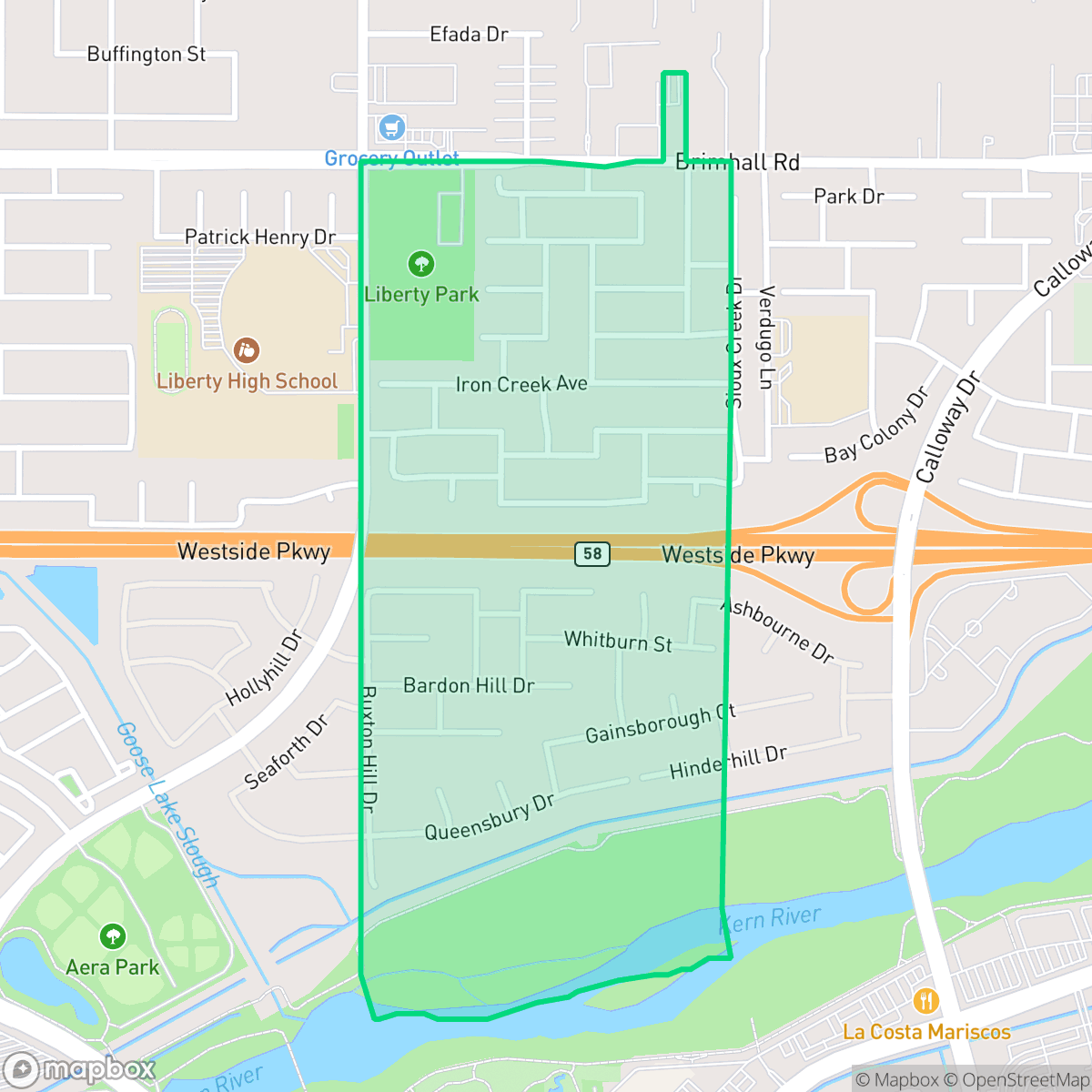
Brighton, Bakersfield
Updated June 22, 2026 · 1,939 residents
Brighton is a quiet, suburban enclave in Bakersfield known for its high walkability and excellent air quality. The neighborhood offers a peaceful, residential atmosphere with well-maintained green spaces and minimal industrial presence.
Key Highlights
About Brighton
Brighton is a predominantly residential community characterized by quiet streets and a suburban layout that balances open green spaces with residential density. According to iHuus data, the area benefits from superior air quality and a lack of industrial proximity, contributing to a serene living environment. While the neighborhood is situated near a major highway, acoustic comfort remains relatively high for the region, providing a stable backdrop for its residents. The area is best suited for those seeking a tranquil lifestyle with access to local amenities like neighborhood dining and community centers. While the neighborhood boasts exceptional walkability, its overall liveliness is low, reflecting its status as a calm, family-oriented retreat. Prospective residents should be aware of regional fire safety risks, though the area maintains strong health insurance coverage and stable educational options through the Rosedale Union and Kern High School districts.
Neighborhood Scores Across 15 Qualities
Residential spacing provides a moderate level of separation between neighbors, which is slightly higher than the Bakersfield average according to iHuus data.
Pedestrian infrastructure is exceptional in this area, featuring wide sidewalks on both sides of the street and numerous safe crossings. According to iHuus data, the neighborhood offers significantly better walkability than the Bakersfield average.
Large homes and frequent upscale amenities define the area's landscape. According to iHuus data, the neighborhood offers a higher level of visual quality compared to the Bakersfield average.
Accessible green spaces and wide paths provide safe walking areas away from traffic. According to iHuus data, this area offers better amenities for pet owners than the Bakersfield average.
Open land and scattered residences characterize the landscape, offering a setting that is very similar to the Bakersfield average. This area provides a balance of residential pockets situated near fields and undeveloped spaces according to iHuus data.
Primarily composed of low-density suburban blocks, this area offers a quiet atmosphere but lacks significant pedestrian activity. According to iHuus data, the neighborhood is slightly less lively than the Bakersfield average, with most dining and retail options requiring a vehicle to reach.
A steady hum from nearby busy streets defines the acoustic environment. According to iHuus data, noise levels in Brighton are higher than the average for Bakersfield.
Air quality remains consistently high with minimal health concerns. This level of-clean air is notably better than the Bakersfield average, according to iHuus data.
Industrial facilities and warehouses are entirely absent from this area, providing a residential environment that is more secluded than the Bakersfield average. According to iHuus data, the neighborhood consists of quiet streets and open green spaces without proximity to any hazard sites.
Health insurance coverage among residents is exceptionally high, significantly exceeding the Bakersfield average according to iHuus data.
Voting and census indicators show a significantly more conservative leaning than the Bakersfield city average.
Residents live alongside a balanced mix of young adults, families, and older populations. This demographic spread is slightly more diverse than the average found across Bakersfield.
Flood safety levels in Brighton are significantly higher than the Bakersfield average, though some residual risk remains due to the area's location within a 500-year floodplain. According to iHuus data, property owners should remain aware of potential seasonal water accumulation.
Block-Level Insights for Brighton

iHuus Neighborhood Intelligence Insights
Get block-level neighborhood insights for Brighton
- Street-level scores — see how individual blocks compare, not just neighborhood averages
- Micro-zone boundaries — identify quiet pockets, flood boundaries, and walkable clusters before you visit
- 15 dimensions in full — walkability, noise, air quality, school quality, insurance coverage, population age profile, urban/rural index, and more
- Boundary risk alerts — know if your address sits near a block boundary where scores drop, the kind of detail no listing will ever mention
- School insights — individual school ratings and insights, not just district-level data
- Compare before you commit — side-by-side data across neighborhoods, down to block precision
No credit card required
Compare with Any Neighborhood
| Dimension | Brighton | Amberton |
|---|---|---|
| 🚶 Walkabilityavg 8.36 | ||
| 🔊 Acoustic Comfortavg 3.78 | ||
| 🤫 Privacy Indexavg 5.57 | ||
| 🎨 Visual Appealavg 6.61 | ||
| 🐕 Dog Friendlinessavg 6.03 | ||
| 🗺️ Urban-Rural Indexavg 6.87 | ||
| ✨ Neighborhood Vibeavg 4.25 | ||
| 🏥 Health Insurance Coverageavg 6.62 | ||
| 🌿 Air Qualityavg 8.49 | ||
| 🏭 Industrial Proximityavg 8.26 | ||
| 🌊 Flood Safetyavg 3.54 | ||
| 🗳️ Ideological Leanavg 5.07 | ||
| 👥 Population Age Profileavg 4.44 | ||
| 🔥 Fire Safetyavg 0.11 | ||
| 🏫 School Quality |
Brighton Rankings
School Districts Serving Brighton
Rosedale Union Elementary School District is a solid and stable pillar of the Northwest Bakersfield community, characterized by strong real estate demand and high academic proficiency in its elementary portfolio. While ground truth data indicates a notable performance gap at the middle school level, recent operational reports and community sentiment reflect a well-governed district with stable leadership, transparent financial planning, and a robust culture of student engagement. The district's proactive transition to by-district elections and its focus on specialized student services suggest a mature administrative structure capable of maintaining its reputation as a premier primary education provider in the region.
Schools
Kern High School District is a robust, operationally stable organization that functions as a 'Mixed' portfolio of high-performing flagship schools and underperforming rural campuses. While the district earns praise for its Career Technical Education (CTE), high graduation rates, and competitive athletics, it is hampered by a stark disparity in academic proficiency, with several schools reporting math and reading scores well below state averages. Despite these academic gaps, strong teacher retention strategies and successful specialized programs like the Academic Decathlon indicate a stable corporate foundation that manages a diverse and geographically vast student population effectively, though it lacks the uniform excellence required for a higher rating.
Schools
Panama-Buena Vista School District is a high-growth, financially stable organization with a split personality: it hosts some of Bakersfield's most prestigious elementary schools alongside several critically underperforming junior high campuses. The district maintains strong community support, evidenced by successful bond measures and a celebrated music program, and state data indicates improving math proficiency and declining absenteeism. While it remains a destination district for many families due to its 'private school feel' in affluent pockets, the significant academic disparity and social climate concerns at the junior high level indicate a district in transition, struggling to maintain consistency across its expanding portfolio.
Schools
School Insights for Brighton
Below average outcomes; significant attendance and academic challenges.
School Insights
See what's really behind every school rating near Brighton
- Individual school ratings — each school's own score with outcome context, not just a district average
- Enrollment & class size data — student-to-teacher ratio and how it compares to the state average
- Full demographics breakdown — ethnicity and gender composition for every school in the enrollment zone
- Every school in the district — all schools within the enrollment boundary ranked by rating, not just the closest one
- Grade levels & benchmarks — elementary through high school, with below/above state-average flags
No credit card required