The Colony, Anaheim
Updated June 22, 2026 · 32,519 residents
The Colony is a historic district defined by its dense grid of preserved architecture and exceptional walkability. Residents enjoy a central location with immediate access to a comprehensive sidewalk network, though the area experiences notable road traffic noise and limited private yard space.
Key Highlights
About The Colony
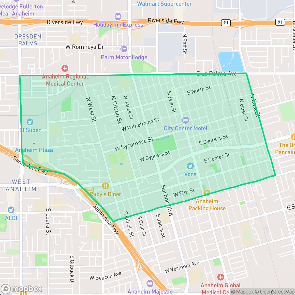
The Colony in Anaheim, California, is a historic neighborhood whose boundaries—North, South, East, and West Streets—match the original 1,200-acre German viticulture colony established in 1857 by the Los Angeles Vineyard Society. Designated in 1997 as Anaheim's first and largest historic district, the neighborhood features more than 1,000 qualified historic structures showcasing Craftsman, Spanish Colonial, Mission Revival, and Queen Anne architectural styles. A central landmark is Founders' Park, which hosts the 1857 Mother Colony House—the oldest remaining wood-framed building in Orange County and California Historical Landmark No. 201—alongside the 1894 Queen Anne-style Woelke-Stoffel House and a heritage Moreton Bay Fig tree. Today, the neighborhood's entryways are marked by four distinct Anaheim Colony Monuments.
The neighborhood serves as a dense suburban hub where residential streets intersect with diverse local dining and cultural sites. Its layout prioritizes pedestrian movement, featuring a continuous grid of sidewalks that makes local errands convenient. While the area maintains a strong sense of place through its historic roots, the current environment is characterized by a mix of single-family homes and multi-story apartment complexes that create a high-density living experience.
Prospective residents should note that the area presents specific trade-offs regarding privacy and acoustic comfort. Homes are often situated in close proximity to one another, and road traffic contributes to higher noise levels throughout the day. While the neighborhood is free from heavy industrial hazards, families should consider the current academic performance of the local school districts, which face significant fiscal and operational challenges. It is best suited for those who prioritize walkability and proximity to community amenities over expansive private outdoor space or quiet suburban solitude.
Neighborhood Scores Across 15 Qualities
Residential spacing is somewhat dense, with many homes and apartment complexes situated in close proximity to one another. This level of privacy is slightly lower than the Anaheim average due to the prevalence of shared walls and narrow gaps between structures.
Extensive sidewalk networks and marked crosswalks provide excellent pedestrian connectivity throughout residential and commercial streets. This level of accessibility for foot traffic is notably higher than the Anaheim average.
Uniform tract housing and apartment complexes define the area, which offers slightly less visual variety than the city average. Most lots feature modest yards and consistent rooflines, though some properties include private backyard pools.
Public walking options for pets are somewhat limited as much of the greenery is confined to private backyards. While some residential streets offer sidewalk verges and proximity to local sports fields, the available public space for dogs is below the Anaheim average according to iHuus data.
A dense suburban landscape prevails here, characterized by a blend of single-family homes and multi-story apartment complexes. This layout is largely consistent with the broader Anaheim area.
A mix of quiet suburban blocks and lively commercial pockets provides more social activity than the Anaheim average. While some areas feature diverse dining and social hubs, other parts of the neighborhood remain car-dependent with sparse walking options.
Frequent noise from nearby freeway corridors and railroad tracks is a common characteristic of this area. According to iHuus data, acoustic levels in The Colony are notably higher than the Anaheim average.
Air quality in this area remains mostly clean with only rare instances of elevated readings; however, it is slightly lower than the Anaheim average according to iHuus data.
Industrial activity is very low in this area, consisting primarily of residential and light commercial uses. Residents will find almost no heavy industrial hazards or large warehouses here, which is consistent with the broader Anaheim area according to iHuus data.
Health insurance enrollment among residents is lower than the average for Anaheim. This reflects a higher proportion of uninsured individuals in the area according to iHuus data.
Voting patterns and census indicators reflect a predominantly liberal political leaning that is notably higher than the Anaheim average, according to iHuus data.
Residents live alongside a balanced mix of young adults, families, and older populations. This demographic spread is very similar to the broader Anaheim area, according to iHuus data.
Significant flood risk exists due to the area's location within a designated floodplain, which is notably higher than the Anaheim average. Residents should expect that flood insurance will likely be required for properties in this zone according to iHuus data.
Block-Level Insights for The Colony

iHuus Neighborhood Intelligence Insights
Get block-level neighborhood insights for The Colony
- Street-level scores — see how individual blocks compare, not just neighborhood averages
- Micro-zone boundaries — identify quiet pockets, flood boundaries, and walkable clusters before you visit
- 15 dimensions in full — walkability, noise, air quality, school quality, insurance coverage, population age profile, urban/rural index, and more
- Boundary risk alerts — know if your address sits near a block boundary where scores drop, the kind of detail no listing will ever mention
- School insights — individual school ratings and insights, not just district-level data
- Compare before you commit — side-by-side data across neighborhoods, down to block precision
No credit card required
Compare with Any Neighborhood
| Dimension | The Colony | Anaheim Hills |
|---|---|---|
| 🚶 Walkabilityavg 8.73 | ||
| 🔊 Acoustic Comfortavg 2.38 | ||
| 🤫 Privacy Indexavg 4.69 | ||
| 🎨 Visual Appealavg 6.56 | ||
| 🐕 Dog Friendlinessavg 5.82 | ||
| 🗺️ Urban-Rural Indexavg 6.49 | ||
| ✨ Neighborhood Vibeavg 4.29 | ||
| 🏥 Health Insurance Coverageavg 6.54 | ||
| 🌿 Air Qualityavg 8.7 | ||
| 🏭 Industrial Proximityavg 8.17 | ||
| 🌊 Flood Safetyavg 2.02 | ||
| 🗳️ Ideological Leanavg 7.03 | ||
| 👥 Population Age Profileavg 4.79 | ||
| 🔥 Fire Safetyavg 0.06 | ||
| 🏫 School Quality |
The Colony Rankings
School Districts Serving The Colony
Anaheim Elementary School District is a 'Mixed/Transition' district characterized by persistent academic challenges offset by strong operational initiatives and community partnerships. While state assessment data shows proficiency levels significantly below state averages, the district has successfully implemented specialized literacy programs, recovered substantial state funding for mental health, and maintained stable community relations through high-visibility corporate partnerships. Despite the presence of several low-performing campuses and ongoing leadership evaluations, the district remains solvent and focused on long-term literacy and bilingual education improvements.
Schools
Anaheim Union High School District is currently in a distressed state, characterized by a 'fiscal cliff' that has resulted in mass layoff notices for over 100 staff members and significant community unrest. While the district maintains a few 'Blue Chip' assets like Oxford Academy and Cypress High, there is a severe academic crisis in its feeder system, with nearly a third of its schools—predominantly junior highs—receiving the lowest possible rating (1/10). Declining enrollment and the exhaustion of one-time federal funds have created a precarious financial environment that overshadows its innovative dual-enrollment programs and vocational pathways, indicating a period of significant contraction and operational instability.
Schools
School Insights for The Colony
Below average outcomes; significant attendance and academic challenges.
School Insights
See what's really behind every school rating near The Colony
- Individual school ratings — each school's own score with outcome context, not just a district average
- Enrollment & class size data — student-to-teacher ratio and how it compares to the state average
- Full demographics breakdown — ethnicity and gender composition for every school in the enrollment zone
- Every school in the district — all schools within the enrollment boundary ranked by rating, not just the closest one
- Grade levels & benchmarks — elementary through high school, with below/above state-average flags
No credit card required