Southeast Anaheim, Anaheim
Updated · 41,260 residents
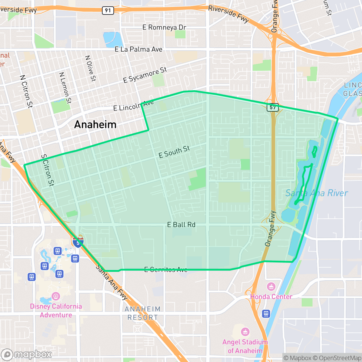
Southeast Anaheim is a dense, highly walkable residential community defined by its mid-century housing and active green spaces like Boysen Park and the Anaheim Coves. While the area offers convenient pedestrian access to local amenities, residents should expect significant road noise and relatively close proximity to neighboring homes.
Key Highlights
About Southeast Anaheim
Southeast Anaheim, bordered by Central Anaheim, Interstate 5, and the Santa Ana River, developed rapidly following the mid-20th-century openings of Disneyland and Angel Stadium. This boom transformed the area's agricultural landscape into residential tracts featuring classic mid-century ranch and bungalow-style homes. A central neighborhood landmark is the 24.6-acre Boysen Park, established in the 1960s. It is named after Rudolph Boysen, the local horticulturist who created the boysenberry and served as Anaheim's first park superintendent. Known locally as "Airplane Park," it features a permanently grounded 1954 U.S. Navy Cougar jet on its playground. Along the neighborhood's eastern edge, the Anaheim Coves nature park and trail system represents a major ecological restoration, transforming the former Burris Basin gravel quarry into a vibrant groundwater recharge facility and wildlife habitat.
The neighborhood features a dense suburban layout that blends traditional single-family homes with multi-family apartment complexes. Its grid-based street system provides high walkability, allowing residents to navigate between residential blocks and local institutional hubs with ease. The area maintains a balanced mix of suburban quiet and light commercial activity, supported by proximity to major transit corridors and natural restoration projects that provide essential outdoor space.
Prospective residents should consider that the area experiences elevated noise levels primarily due to consistent road traffic. While the neighborhood offers strong pedestrian infrastructure, privacy is limited by the close spacing of residential structures and shared-wall housing. Educational options vary significantly across the local school districts, making it important for families to research specific school zones. The area is best suited for those prioritizing accessibility and a central location over expansive private yards or total silence.
Neighborhood Scores Across 15 Qualities
Housing layouts vary between detached single-family homes with private yards and dense apartment clusters with shared walls. According to iHuus data, the level of separation between neighbors is roughly average for the city.
Comprehensive sidewalk networks and clear crosswalks facilitate safe pedestrian movement across most residential and commercial streets. While the area features a continuous grid of accessible paths that is better than the Anaheim average, a large multi-lane freeway corridor serves as a significant barrier to navigation.
Residential views range from well-manicured, affluent properties with private pools to denser, standard tract housing. This level of visual variety is slightly below the Anaheim average.
Public walking areas and green verges are less common here than in the rest of Anaheim. While some residents benefit from nearby school fields and large parks, much of the neighborhood greenery is confined to private, fenced backyards.
Residential streets and green spaces exist in roughly equal measure with industrial zones, though the area feels slightly less green than the city average. The landscape features a diverse mix of single-family homes, multi-story apartments, and large-scale warehouse footprints.
A diverse mix of dining, industrial units, and green spaces provides a balanced level of activity that is slightly more vibrant than the city average. While many social hubs and eateries are available, the area remains largely car-dependent due to the spread-out nature of local businesses.
Constant sound from nearby railroad tracks and heavy freeway traffic characterizes this area. According to iHuus data, acoustic conditions are slightly more disruptive than the typical Anaheim neighborhood.
Air quality in this area is mostly clean with rare instances of elevated readings; however, it remains slightly below the Anaheim city average according to iHuus data.
Residential life remains largely uninterrupted by heavy industry, as the area consists primarily of residential, commercial, and retail structures. While some large warehouses and logistics hubs are located in specific quadrants, the overall level of industrial proximity is slightly lower than the Anaheim average.
Health insurance access among residents is slightly lower than the city average. According to iHuus data, a significant portion of the population remains uninsured.
Political leanings in this area trend more liberal than the Anaheim average. According to iHuus data, the neighborhood maintains a liberal majority with a modest opposing presence.
Residents live alongside a balanced mix of young adults, families, and older populations. This demographic spread is largely in line with the average seen across Anaheim.
Flood risk is notably higher than the Anaheim average due to the area's location within a designated floodplain. According to iHuus data, residents may find that flood insurance is typically required for properties in this zone.
Address-Level Insights for Southeast Anaheim


iHuus Neighborhood Intelligence Insights
Get address-level neighborhood insights for Southeast Anaheim
- Street-level scores — see how individual blocks compare, not just neighborhood averages
- Micro-zone boundaries — identify quiet pockets, flood boundaries, and walkable clusters before you visit
- 15 dimensions in full — walkability, noise, air quality, school quality, insurance coverage, population age profile, urban/rural index, and more
- Boundary risk alerts — know if your address sits near a block boundary where scores drop, the kind of detail no listing will ever mention
- School insights — individual school ratings and insights, not just district-level data
- Compare before you commit — side-by-side data across neighborhoods, down to block precision
No credit card required
Compare with Any Neighborhood
| Dimension | Southeast Anaheim | Anaheim Hills |
|---|---|---|
| 🚶 Walkabilityavg 8.73 | ||
| 🔊 Acoustic Comfortavg 2.38 | ||
| 🤫 Privacy Indexavg 4.69 | ||
| 🎨 Visual Appealavg 6.56 | ||
| 🐕 Dog Friendlinessavg 5.82 | ||
| 🗺️ Urban-Rural Indexavg 6.49 | ||
| ✨ Neighborhood Vibeavg 4.29 | ||
| 🏥 Health Insurance Coverageavg 6.54 | ||
| 🌿 Air Qualityavg 8.7 | ||
| 🏭 Industrial Proximityavg 8.17 | ||
| 🌊 Flood Safetyavg 2.02 | ||
| 🗳️ Ideological Leanavg 7.03 | ||
| 👥 Population Age Profileavg 4.79 | ||
| 🔥 Fire Safetyavg 0.06 | ||
| 🏫 School Quality |
Southeast Anaheim Rankings
School Districts Serving Southeast Anaheim
School Insights for Southeast Anaheim
Below average outcomes; significant attendance and academic challenges.
School Insights
See what's really behind every school rating near Southeast Anaheim
- Individual school ratings — each school's own score with outcome context, not just a district average
- Enrollment & class size data — student-to-teacher ratio and how it compares to the state average
- Full demographics breakdown — ethnicity and gender composition for every school in the enrollment zone
- Every school in the district — all schools within the enrollment boundary ranked by rating, not just the closest one
- Grade levels & benchmarks — elementary through high school, with below/above state-average flags
No credit card required