Northeast Anaheim, Anaheim
Updated · 48,086 residents
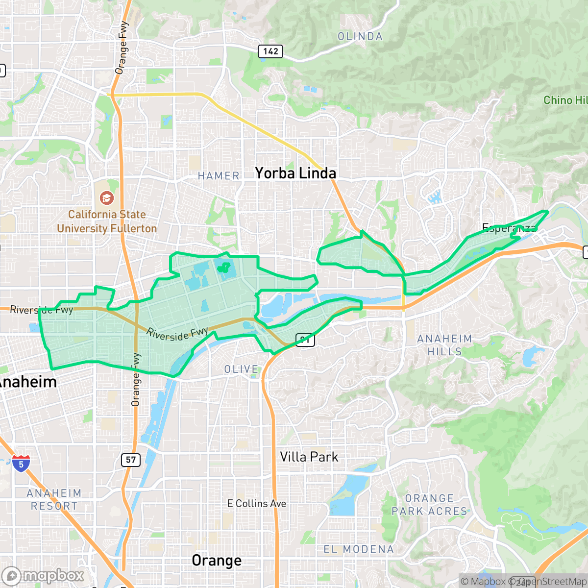
Northeast Anaheim is a dense suburban and industrial community characterized by its mid-century housing and proximity to major logistics hubs. While the area offers high air quality and access to several top-tier schools, residents experience significant noise from nearby freeway traffic and limited privacy due to high-density residential layouts.
Key Highlights
About Northeast Anaheim
Once a vast agricultural landscape, the Northeast Anaheim neighborhood was shaped in the early 20th century by prominent landowner Bennett Payne Baxter, who pioneered innovative irrigation methods for the area's extensive orange groves. Following the 1955 opening of Disneyland, the region transitioned rapidly from agriculture to suburban and industrial development. To fuel this boom, civic leaders established an industrial zone along the newly built SR 91 Riverside Freeway, which attracted major defense aerospace employers like Autonetics (later Rockwell International) in 1959. Today, Northeast Anaheim is a densely populated residential community defined by its post-WWII housing stock, featuring mid-century bungalows and ranch-style homes constructed primarily between 1940 and 1969.
The neighborhood functions as a dense, multifaceted environment that blends residential tracts with large-scale industrial and logistics infrastructure. This area is defined by its post-war suburban design, where tightly spaced homes and apartment complexes sit adjacent to extensive warehouse districts and major transportation corridors. While the landscape is largely quiet and car-oriented, it provides essential access to regional employment hubs and maintains a consistent sidewalk network that facilitates pedestrian movement between residential blocks and local service nodes.
Livability in the area involves distinct trade-offs, particularly regarding environmental factors and housing density. According to iHuus data, residents benefit from high air quality, yet the neighborhood faces challenges related to elevated road noise and a lack of private green space. The educational landscape is highly varied, offering access to elite schools like Woodsboro Elementary and Esperanza High alongside campuses with lower performance ratings. Prospective residents should consider that the community is best suited for those who prioritize proximity to industrial and transit corridors over the seclusion of a traditional, low-density suburb.
Neighborhood Scores Across 15 Qualities
Housing density varies across the area, ranging from closely packed apartment clusters to suburban tracts with shared property lines. This level of residential spacing is roughly comparable to the city average for Anaheim.
Residential streets and cul-de-sacs feature a consistent sidewalk network with clear crosswalks, though major highway and rail infrastructure can create significant barriers for through-neighborhood travel. This level of connectivity is slightly lower than the average for Anaheim.
Manicured yards and a high density of private backyard pools contribute to a visual landscape that is slightly more upscale than the Anaheim average. According to iHuus data, certain pockets feature large homes with expansive driveways and well-maintained landscaping.
Access to public green space for pets is roughly average for the city, with opportunities for walking provided by nearby golf courses, riverbed trails, and large sports fields. While some areas feature wide green verges, much of the greenery is located within private fenced backyards.
A blend of dense residential tracts and large-scale industrial warehouses defines this area. The landscape is slightly more developed and built-up than the typical Anaheim average.
Daily activities and dining options are primarily concentrated around major highways and industrial corridors, making the area more functional and car-oriented than the city average. While some walkable paths exist near parks and railways, most social and retail services require a vehicle to reach.
Frequent noise from nearby freeways and railroad tracks characterizes this area. According to iHuus data, acoustic comfort is lower than the typical level found across Anaheim.
Air quality remains consistently high with minimal health concerns for residents. According to iHuus data, the atmosphere in this area is notably cleaner than the average for the city of Anaheim.
Industrial presence is minimal, with only occasional light commercial activity and no significant heavy industry. This area is slightly more influenced by logistics hubs and warehouse traffic than the city average.
Health insurance accessibility is strong in this area, sitting above the Anaheim average according to iHuus data.
Political views in this area are evenly split between conservative and liberal leanings, making it slightly less conservative than the broader Anaheim average according to iHuus data.
A balanced mix of young adults, families, and older residents defines the local demographic. This age distribution is largely consistent with the broader Anaheim area, according to iHuus data.
Properties in this area are situated within a known floodplain, which makes flood insurance typically necessary. According to iHuus data, the risk of flooding here is higher than the city average.
Fire safety infrastructure and coverage in this area are notably lower than the city average, according to iHuus data. Residents should be aware of the reduced availability of immediate fire protection services compared to other parts of Anaheim.
Address-Level Insights for Northeast Anaheim


iHuus Neighborhood Intelligence Insights
Get address-level neighborhood insights for Northeast Anaheim
- Street-level scores — see how individual blocks compare, not just neighborhood averages
- Micro-zone boundaries — identify quiet pockets, flood boundaries, and walkable clusters before you visit
- 15 dimensions in full — walkability, noise, air quality, school quality, insurance coverage, population age profile, urban/rural index, and more
- Boundary risk alerts — know if your address sits near a block boundary where scores drop, the kind of detail no listing will ever mention
- School insights — individual school ratings and insights, not just district-level data
- Compare before you commit — side-by-side data across neighborhoods, down to block precision
No credit card required
Compare with Any Neighborhood
| Dimension | Northeast Anaheim | Anaheim Hills |
|---|---|---|
| 🚶 Walkabilityavg 8.73 | ||
| 🔊 Acoustic Comfortavg 2.38 | ||
| 🤫 Privacy Indexavg 4.69 | ||
| 🎨 Visual Appealavg 6.56 | ||
| 🐕 Dog Friendlinessavg 5.82 | ||
| 🗺️ Urban-Rural Indexavg 6.49 | ||
| ✨ Neighborhood Vibeavg 4.29 | ||
| 🏥 Health Insurance Coverageavg 6.54 | ||
| 🌿 Air Qualityavg 8.7 | ||
| 🏭 Industrial Proximityavg 8.17 | ||
| 🌊 Flood Safetyavg 2.02 | ||
| 🗳️ Ideological Leanavg 7.03 | ||
| 👥 Population Age Profileavg 4.79 | ||
| 🔥 Fire Safetyavg 0.06 | ||
| 🏫 School Quality |
Northeast Anaheim Rankings
School Districts Serving Northeast Anaheim
School Insights for Northeast Anaheim
Below average outcomes; significant attendance and academic challenges.
School Insights
See what's really behind every school rating near Northeast Anaheim
- Individual school ratings — each school's own score with outcome context, not just a district average
- Enrollment & class size data — student-to-teacher ratio and how it compares to the state average
- Full demographics breakdown — ethnicity and gender composition for every school in the enrollment zone
- Every school in the district — all schools within the enrollment boundary ranked by rating, not just the closest one
- Grade levels & benchmarks — elementary through high school, with below/above state-average flags
No credit card required